Wind is the driving force for wind turbines and ships under sail. At the same time, it is a dominant environmental load for many large vessels and offshore structures. The wind field is characterised by variations in space and time. To capture actual 3D wind inshore and offshore, MARIN has added a Lidar wind scanner to its field measurement equipment.
To analyse the dynamic behaviour of ships, platforms and wind turbines, accurate monitoring of the environmental conditions is essential. The deployment of offshore wind turbines with hub heights of up to 130 m, the development of wind assisted propulsion and the operation of high windage vessels such as container vessels and cruise ships in confined waters, require detailed information about the wind field over large areas and heights climbing to 300 m. In particular, the vertical profile of the wind speed and direction has to be taken into account. Additionally, the impact of large buildings, offshore platforms and other vessels, which may divert, shield and reflect the wind, is relevant. For the behaviour of vessels in dynamic mooring and structural analysis, the variations of the wind speed and direction in time also have to be considered. Assumptions used in marine engineering methods such as the use of standard wind profiles and spectra are outdated.
Lidar wind scanner addition
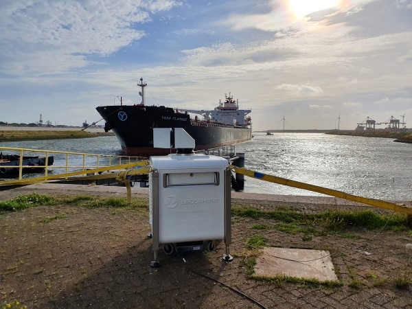
These were the main reasons we decided to acquire a WINDCUBE200S Lidar wind scanner recently, which has been developed and manufactured by Leosphere, a Vaisala company. This instrument is capable of measuring wind fields up to distances of 6 km at a high scanning speed. Doppler Laser Detection and Ranging (Lidar) is a proven technology to measure the speed of particles in the air. The technology developed by Leosphere is based on dedicated high-power fibre laser amplifiers and telecom components at 1,540 nm, and coherent detection. A two-axis scanner head enables arbitrary scanning patterns in 3D space. The scanner facilitates several modes of operation such as starring, horizontal and vertical scans, in addition to combinations thereof.
The instrument is connected with the MARIN offices through a modem that enables data retrieval, as well as remote control of the unit. The measured radial velocities are then post-processed into wind vector plots and time traces.
Application – inshore and offshore, floaters and ships
The WINDCUBE is compact and robust and can be installed inshore and offshore, as well as on floaters and ships. The first application was for the WINDLASS JIP where the Lidar scanner was installed in the Port of Rotterdam to measure the wind environment of moored containerships. Both a horizontal scanning pattern and a vertical scan sequence were programmed. The results were compared to the wind speed and direction measured by conventional wind meters on a nearby 130 m high meteo mast.
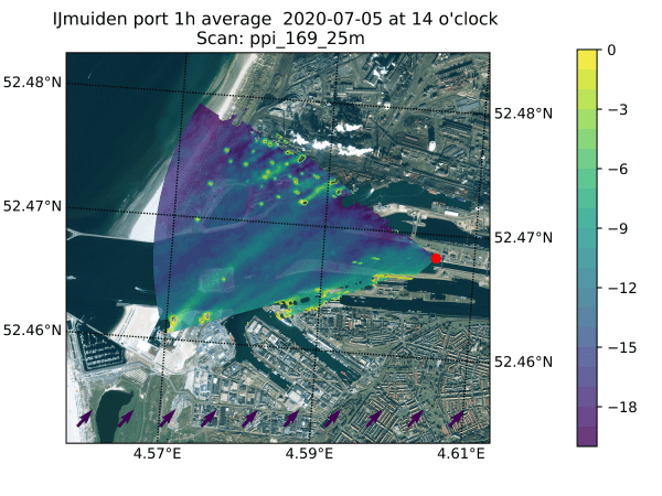
In early July the Lidar scanner was deployed at the locks of IJmuiden to map the wind conditions for high windage vessels passing through. The adjacent picture presents the SW wind measured in the approach area of the locks and clearly shows the shielding effects of a moored cruise ship and large buildings in the southern section. Within the WINDLASS JIP, the instrument will also be deployed in the Ports of Rotterdam, Hamburg, Antwerp and Tenerife.
On board floating wind turbines & buoys
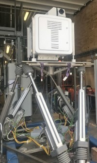
MARIN is also assisting Leosphere with the development and testing of the motion-compensation feature of the WINDCUBE. For this purpose, the instrument was installed on a hexapod simulating the irregular wave induced ship motions in six degrees of freedom. The new feature enables the use of the Lidar scanner on board floating wind turbines, buoys and ships.
Later this year the Lidar scanner will be installed on a wind-assisted vessel to measure the 3D wind encountered by foils.
Speed power trials
Along with windassisted propulsion assessments, the new Lidar scanner will also be used on board ships during speed power trials, enhancing MARIN’s delivery trial services. Conventional wind measurements during such trials are conducted by cup meters or acoustic meters on top of the wheelhouse. The wind speed at that location however, can be strongly affected by the ship’s superstructures. The Lidar scanner enables remote measurement of the undisturbed wind ahead of the vessel.
If you are interested in one of the aforementioned applications or in the use of the Lidar wind scanner for your project please contact Gijs Struijk, g.d.struijk@marin.nl.


